| OSTASIEN Verlag | |
| Kontakt | |
| Reihen | |
| Zeitschriften | |
| Gesamtverzeichnis | |
| Impressum | |
|
|
| Cover (PDF) | |
| Buchvorstellung (PDF) | |
Eurasian Historical Geography as Reflected in Geographical Literature and in Maps |
|||
Nurlan Kenzheakhmet |
|||
Deutsche Ostasienstudien 24 |
|||
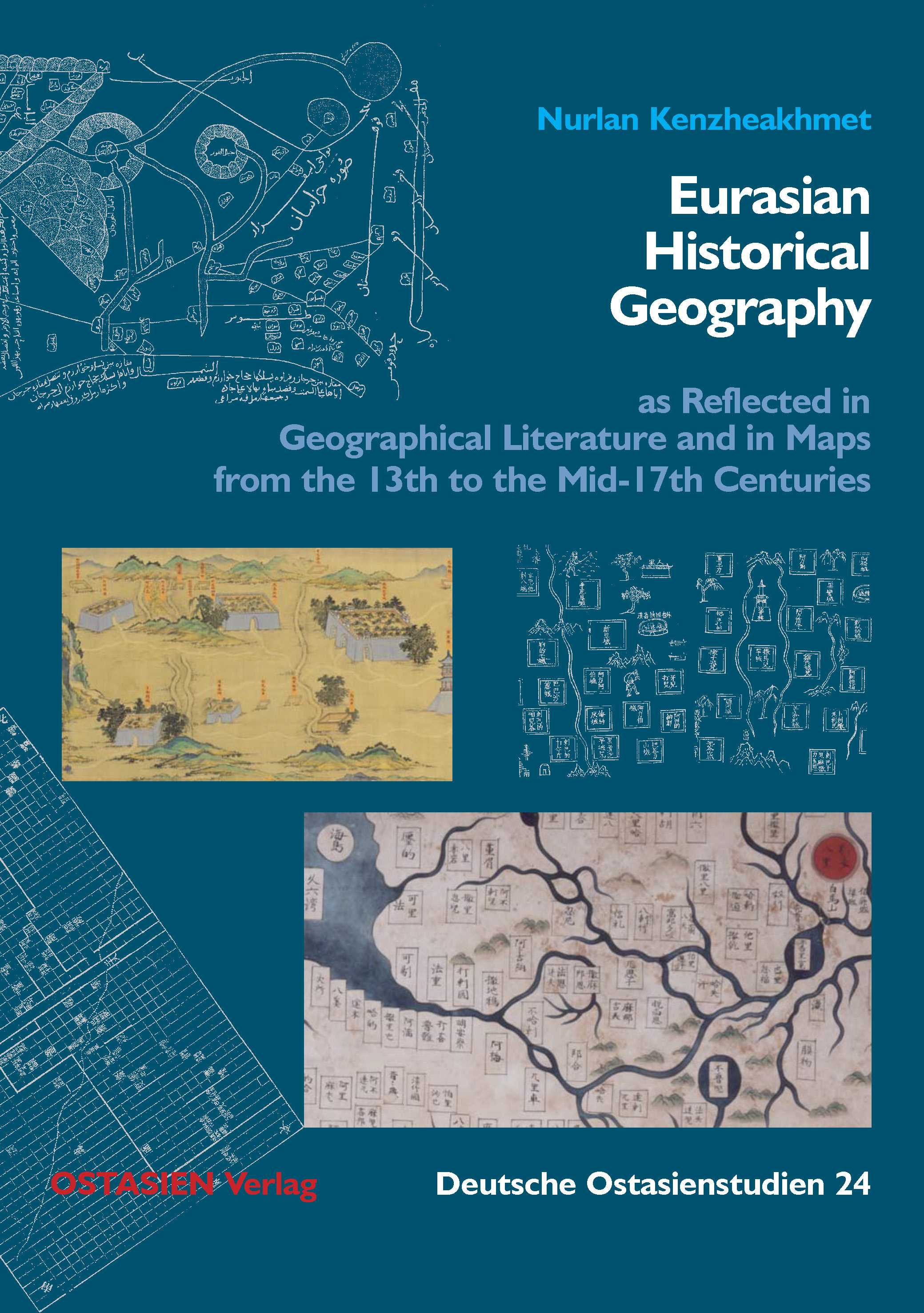
This monograph focuses on two geographical texts, the Kangnido, the oldest surviving detailed Chinese “world map”, compiled in Korea in 1402, and a travelogue describing a route from China to the Mediterranean, first published in 1546. The Kangnido map, the full title of which can be rendered in English as “Comprehensive Map of Integrated Lands and Regions of Historical Countries and Their Capitals”, is based on earlier Chinese maps drawn by cartographers of the Mongol Empire, who relied primarily on maps and descriptions from the Islamic world for the names of places in regions outside China. As for the place names relating to Africa, Europe, and Western Asia, the map-makers drew the information they needed from medieval maps and geographical works in Arabic, Persian and other Western and Central Asian languages, as, e.g., al-Iṣṭakhrī’s Kitāb al-Masālik wa-’l-mamālik (Book of Routes and Realms) and ibn Ḥawqal’s Kitāb ṣūrat al-arḍ (Book of the Face of the Earth) dating from the 10th century, and transcribed the required place names into Chinese characters. The western part of this map can therefore justly be called a crystallization of the merging of Chinese and Muslim geography, in other words, this section of the map is the result of a multicultural integration. The travelogue, consisting of a set of maps entitled “Xiyu tudi renwu tu” (Atlas of the Territories and Peoples of the Western Regions) and an annotated itinerary entitled “Xiyu tudi renwu lüe” (Outline of the Territories and Peoples of the Western Regions), were included in the same chapter of the Shaanxi tongzhi (Gazetteer of Shaanxi Province), the province from which the caravans set out westward on the Silk Roads. Based on a thorough analysis of this 16th-century travelogue, the author convincingly shows that a famous scroll consisting of more than 30 meters length, referred to by some scholars as Menggu shanshui ditu (Mongolian Landscape Map) and was by others titled Silu shanshui tu (Silk Road Landscape Map), can also be evidenced to be a product of the Ming Dynasty. The results presented by the author with regard to the Kangnido world map as well as those relating to the descriptions of the Silk Roads demonstrate how strong China’s interest in the outside world must have been before the government had decided to isolate China from the rest of the world for the centuries to come. |
|||
Nurlan Kenzheakhmet was born in Xinjiang, China, to a Kazakh family, received his PhD for works on history (Moscow, 2005) and archeology (Beijing, 2007) and mastering eight languages in the process. He has authored many works on the archeology, history and historical geography of Central Asia. Supported by research grants from the Alexander von Humboldt Foundation and the Gerda Henkel Foundation starting in 2012, he worked for six years at the University of Bonn to prepare this monograph. He is presently professor of Central Asian History at the Eurasian Research Institute of Khoja Akhmet Yassawi International Kazakh-Turkish University and research-professor at the Abai Kazakh National Pedagogical University. He is currently working on a project on Ming and Qing period cartography at Harvard University. Nurlan Kenzheakhmet also published European-Chinese Imperial Maps and Gazetteers Related to the Qazaq Khanate and Its Adjacent Regions from the 16th to the 19th Centuries with OSTASIEN Verlag in 2023. |
|||
Contents |
|||
Foreword |
|||
Acknowledgements |
|||
1 |
The Place Names of the Western Section on the Kangnido |
||
1.0 |
Introduction |
||
1.0.1 |
Historico-Cartographical Background |
||
1.0.2 |
The Western Section of the Kangnido and the Maps of the Balkhī School: Towards a New Understanding of the Sources of the Kangnido |
||
1.0.2.1 |
The Maps in the Tradition of the Balkhī School and the Kangnido |
||
1.0.2.2 |
Maḥmūd al-Kāshgharī’s Map and the Kangnido |
||
1.0.2.3 |
Al-Idrīsī’s Maps and the Kangnido |
||
1.0.2.4 |
The Two Tangshu (Book of the Tang [Dynasty]) and the Kangnido |
||
1.0.2.5 |
Shengchao hunyi fangyu shenglan and the Kangnido |
||
1.0.2.6 |
Jamāl al-Dīn and the Kangnido |
||
1.0.2.7 |
Dushi and Kangnido |
||
1.0.2.8 |
The Influence of Al-Idrīsī’s Maps on European and Jesuit Maps from the 17th to 18th Centuries |
||
1.0.2.9 |
Conclusion |
||
1.1 |
Africa |
||
1.1.1 |
Egypt (Miṣr) |
||
1.1.2 |
Maghreb (al-Maghreb), the Northern Part of Africa West of Egypt |
||
1.1.3 |
The Nile, Jabāl al-Qamar and the Islands of South and Southeast Africa |
||
1.2 |
Europe |
||
1.2.1 |
Spain (Al-Andalūs) |
||
1.2.2 |
Central Europe |
||
1.2.3 |
The Italian Peninsula and Its Islands |
||
1.2.4 |
The Balkans |
||
1.2.5 |
The Crimean Peninsula |
||
1.3 |
Asia |
||
1.3.1 |
Asia Minor (Anatolia) |
||
1.3.2 |
Syria (Bilad al-Shām) |
||
1.3.3 |
Arabia |
||
1.3.4 |
Upper Mesopotamia (al-Jazīrah) |
||
1.3.5 |
Lower Mesopotamia (al-’Irāq) |
||
1.3.6 |
Khūzistan |
||
1.3.7 |
Fārs and the Islands of the Persian Gulf |
||
1.3.8 |
Kirmān |
||
1.3.9 |
Sijistān |
||
1.3.10 |
Sind (al-Sind) |
||
1.3.11 |
Hind (al-Hind) |
||
1.3.12 |
Armenia, Arrān, and Azerbaijan |
||
1.3.13 |
Central Persian Mountains (al-Jibāl) |
||
1.3.14 |
Al-Daylām and Tabaristān |
||
1.3.15 |
Caspian Sea (Bahr al-Khazar) and Aral Sea (Buḥayrat Khwārazm) |
||
1.3.16 |
Cuman Steppe (Dasht-i Qipchāq), Mongolia, and Adjacent Regions |
||
1.3.17 |
Transoxiana (Māwarā’an-nahr) |
||
1.3.18 |
Khurāsān |
||
1.3.19 |
Badakhshān, Kashmir and Tibet |
||
1.3.20 |
Beshbalyq |
||
1.3.21 |
Southern India, Burma (Myanmar), Northern Mainland Southeast Asia (Annam, Siam) and Yunnan |
||
1.3.22 |
Inner Asia on the Kangnido: Contexts for Early Chinese Knowledge of Inner Asia |
||
2 |
“Xiyu tudi renwu tu”, “Xiyu tudi renwu lüe” and Menggu shanshui ditu |
||
2.0 |
Introduction |
||
2.1 |
“Xiyu tudi renwu lüe” and “Xiyu tudi renwu tu” |
||
2.1.1 |
The Chinese perspective of the “Xiyu tudi renwu lüe” and of the “Xiyu tudi renwu tu” |
||
2.1.2 |
The Authors of the “Xiyu tudi renwu lüe” and of the “Xiyu tudi renwu tu” |
||
2.1.3 |
Dating the “Xiyu tudi renwu lüe” and the “Xiyu tudi renwu tu” |
||
2.1.4 |
The Colored Atlas Menggu shanshui ditu |
||
2.2 |
Identification of the Geographical Names of the “Xiyu tudi renwu lüe”, the “Xiyu tudi renwu tu” and the Menggu shanshui ditu |
||
2.2.1 |
English Translation of the “Xiyu tudi renwu lüe” Section of the Shaanxi tongzhi |
||
2.2.1.1 |
Notes on the Translation of the “Xiyu tudi renwu lüe” |
||
2.2.1.2 |
Translation of the “Xiyu tudi renwu lüe” |
||
2.2.2 |
Notes to Place Names of the “Xiyu tudi renwu lüe” |
||
Concluding Remarks |
|||
Reference Tables |
|||
A.1 |
Names on the Kangnido |
||
A.2 |
Names of Inner Asia on the Kangnido |
||
A.3 |
Place Names in the “Xiyu tudi renwu lüe”, the Bianzheng kao, the “Xiyu tudi renwu tu”, the Gansu zhen zhanshou tulüe and the “Xiyu tulüe” |
||
A.4 |
Place Names on the Menggu shanshui ditu |
||
List of Illustrations |
|||
List of Tables |
|||
Bibliography |
|||